
Today I took this phone snapshot of a great plane trail. It was about 3pm, looking about West. You can click on any image to enlarge it.

A quick check [1] showed it was about 12km up. I’d guess it was about 30 degrees above the horizon. I wondered how far away it was ; meaning what point on the Earth was it directly over when I took this? So, time for some olde world maths. First – of course – draw it:
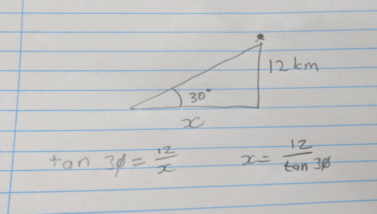
I need to find x, the distance in km. Time to go really old school and use logarithms [2] aka logs.
x = 12/tan(30 degrees). I’m dividing so I need to subtract the logs: log(x) = log(12) – log(tan 30 degrees)
Off to the PDF of the Formulas and Tables book I found online – from 1968 🙂
log(x) = log(12) - log(tan 30 degrees)
log(x) = 1.0792 - (9.7614 - 10.0000)
# that's the way the book said to do it for log(tan x) ;  [value in table - 10.0000]
log(x) = 1.0792 - (-0.2386)
log(x) = 1.0792 +   0.2386)
log(x) = 1.3178
Antilog(.3178) = 2075 + 4 = 2079
Now, the first 1 in my 1.3178 means I have (1+1) = 2 digits before the decimal in my final answer.
So it is therefore: 20.79 km
Crosscheck with the very modern Flightaware website [3] which said that at 15:02 (when I took the photo), the flight was at Latitude and Longitude:
Sat 15:02:23 -37.8623 144.6534
So off to Google Earth, draw that point and a point for me in Williamstown. Finally, get Google Earth to measure the ground distance:
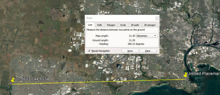
With the result being 21.39 km. Not bad. Not bad at all.
References:
[1] FlightRadar24 app on Android used. BTW this was QF64 from Johannesburg to Sydney.
[2] Have re-discovered how to do Logarithms as part of another exercise involving studying a calculation which was part of an 1860s gold claim dispute at Walhalla. I had learnt them back in the early 70s, then forgot as calculators took over.
[3] http://flightaware.com/live/flight/QFA64/history/20171208/1650Z/FAOR/YSSY/tracklog